The Great Port Chessboard: Beijing’s Indo-Pacific Gambit and the Art of Hedging
As Beijing expands its Indo-Pacific footprint, shipping lanes face a new era of "hedging" and strategic competition that will redefine maritime logistics.
TL;DR
China is transforming commercial port access in Djibouti, Sri Lanka, and Pakistan into a persistent naval presence across the Indian Ocean.
Regional nations are adopting a "hedging" strategy, prioritizing economic opportunity while resisting total alignment with any single superpower.
Allied responses are shifting away from direct containment toward "shaping" the strategic environment through enhanced intelligence sharing and undersea monitoring.
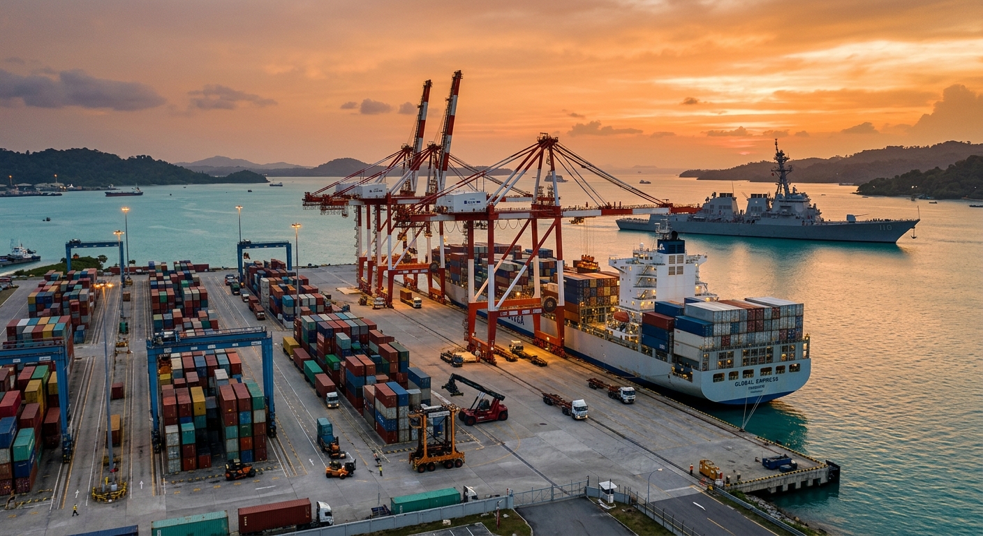
Beijing is no longer just building piers; it is building a permanent seat at the head of the Indo-Pacific table. The expansion of the Djibouti naval base and deepening footprints in Gwadar and Hambantota signal a shift from seasonal visits to a persistent naval presence. For the commercial shipping industry, this means navigating a sea where the line between a merchant terminal and a military outpost is becoming increasingly blurry. This isn't a Cold War-style containment race, but a high-stakes game of regional "hedging" where everyone wants China’s investment but no one wants its command.
The Djibouti-to-Gwadar Corridor
China’s maritime ambitions have graduated from theory to reinforced concrete. The naval base in Djibouti, once a modest logistics point for anti-piracy missions, now features piers capable of docking massive aircraft carriers. This expansion transforms a "support facility" into a power projection hub that sits directly on the throat of the Bab el-Mandeb strait. It is the architectural equivalent of a "permanent resident" visa for the People’s Liberation Army Navy (PLAN) in the Indian Ocean.
Further east, the ports of Gwadar in Pakistan and Hambantota in Sri Lanka represent the commercial-military hybrid model. While these facilities primarily handle containers and bulk goods, their deep-water berths and strategic locations offer the PLAN critical "dual-use" capabilities. Beijing provides the capital for infrastructure that regional governments desperately need, but the fine print often includes long-term leases that look remarkably like sovereign outposts. It is a landlord-tenant relationship where the tenant has a very large security detail.
The proximity of these ports to the world's most critical energy lanes is not an accident. By securing access points at both ends of the Indian Ocean, Beijing creates a safety net for its energy imports. This "persistent presence" ensures that in the event of a global crisis, the PLAN is already on-site rather than racing from the South China Sea. For commercial operators, this means the Indian Ocean is no longer a neutral highway but a monitored corridor.
Regional capitals from Colombo to Jakarta are mastering the art of the geopolitical "swipe left." They want the investment dollars flowing from the Belt and Road Initiative but remain deeply allergic to the idea of total alignment. This "hedging" strategy allows smaller nations to extract maximum economic value while maintaining their security partnerships with the West. It is a delicate balancing act that treats superpowers like competing utility providers rather than ideological leaders.
This reluctance to pick a side complicates the traditional alliance models that Washington and Canberra prefer. If a regional state refuses to grant exclusive access to either side, the Indo-Pacific remains a patchwork of competing influences. This fragmentation prevents any single power from establishing a total maritime hegemony. However, it also creates a landscape where "collective response" is a slow and bureaucratic nightmare.
For logistics managers, this hedging means that port stability is tied to the local government’s ability to keep both Beijing and Washington happy. A sudden shift in a host nation's political winds can lead to sudden regulatory changes or "security audits" that delay cargo. The maritime industry must now account for the "sovereignty premium"—the cost of doing business in ports that are actively trying to avoid becoming pawns in a larger game. It is a world where the shipping manifest is increasingly overshadowed by the diplomatic cable.
Chokepoints and the Toll of Influence
The Indo-Pacific is defined by its bottlenecks. The Strait of Malacca, the Bab el-Mandeb, and the Strait of Hormuz are the cardiovascular system of global trade. Beijing’s push into these areas isn't just about naval glory; it’s about ensuring the tap stays open. When a massive percentage of your energy imports passes through a single narrow waterway, you don't just hope for the best; you send a fleet to watch the gate. This focus on chokepoints creates a "proximity risk" for commercial shipping that few carriers are prepared to price into their contracts.
As naval exercises and patrols increase in these narrow lanes, the margin for error for merchant vessels shrinks. A miscalculated maneuver by a destroyer or a sudden "no-go" zone for a missile drill can send freight rates and insurance premiums into a tailspin. We are entering an era where the "freedom of navigation" is no longer a given but a negotiated reality. The sea lanes are becoming crowded with actors who have very different definitions of "international waters."
The economic implications of this "chokepoint competition" are profound. Carriers must now weigh the efficiency of the shortest route against the geopolitical risk of transiting through increasingly crowded naval zones. If Beijing establishes a persistent presence in the Indian Ocean, it gains the ability to "shape" the flow of trade without firing a single shot. The mere threat of a regulatory slowdown or a safety inspection can be used as a lever of statecraft. For the logistics professional, this means that "transit time" is now a geopolitical variable.
"In the Indo-Pacific, a port is rarely just a port; it is a strategic anchor in a sea of shifting loyalties."
The "Shaping" Strategy: Australia’s Playbook
Canberra has realized that trying to block China’s maritime expansion is like trying to hold back the tide with a broom. Instead, the focus has shifted to "shaping" the environment. This involves reinforcing existing partnerships and ensuring that regional states have options other than Beijing’s checkbook. It is a strategy of "competitive offer" rather than "direct denial." By providing high-quality infrastructure and transparent security cooperation, Australia and its partners aim to keep the region "open and inclusive."
This shift requires a massive increase in intelligence sharing and maritime domain awareness. If you can't stop the ships from coming, you at least want to know exactly what they are carrying and where they are going. This leads to a deeper integration of naval and commercial data. The Indo-Pacific is becoming the most scrutinized body of water on the planet, with sensors, satellites, and undersea cables monitoring every hull that passes.
For the shipping industry, this "shaping" strategy means more eyes on the water. While this can improve safety and security against piracy, it also means that "privacy" at sea is a thing of the past. Data that was once internal to a shipping line is now of intense interest to national security agencies. The "shaping" of the strategic environment is, in many ways, a battle for data supremacy. Whoever has the clearest picture of the ocean floor and the surface traffic wins.
The Silent Front: Undersea Surveillance
The competition isn't just happening on the surface. The undersea domain is the new frontier for Indo-Pacific security. As China expands its naval presence, the focus on submarine detection and cable security has intensified. The Indian Ocean floor is a spiderweb of fiber-optic cables that carry the world’s data. Protecting these—or being able to tap into them—is a core strategic objective for every major power in the region.
Australia and India are deepening their cooperation in undersea surveillance, using advanced sonar and autonomous underwater vehicles (AUVs). This "undersea shield" is designed to monitor PLAN submarine movements and ensure that the "persistent presence" doesn't include undetected threats. For the commercial world, this means that the routes taken by cable-laying ships and deep-sea mining vessels are now part of the geopolitical map. The ocean floor is no longer a silent void but a contested data highway.
This focus on the deep sea also impacts the development of port infrastructure. Ports are no longer just evaluated for their draft and crane capacity; they are scrutinized for their digital hygiene. If a port’s data backbone is built with hardware from a high-risk vendor, it may be excluded from certain Western security networks. The undersea competition is forcing a decoupling of digital infrastructure that will eventually impact how shipping data is processed and shared across borders.
Risk Management in Contested Waters
For the average freight forwarder, geopolitical risk used to be a footnote in an annual report. Today, it is a daily operational reality. The expansion of Chinese naval activity means that traditional routes are becoming more militarized. When a joint naval exercise shuts down a transit lane for 48 hours, the ripple effects are felt across the entire supply chain. Schedule reliability, already a fragile metric, is now at the mercy of operational proximity.
This proximity increases the likelihood of "gray zone" incidents—non-military actions that disrupt trade without crossing the threshold of war. Think of a sudden "environmental inspection" that holds up a tanker or a "cybersecurity drill" that slows down a terminal’s operating system. These are the tools of shaping the environment. They don't require missiles, just a little bit of administrative friction applied at the right chokepoint. The industry must now account for these "invisible" delays that don't show up on a standard AIS feed.
The challenge for the industry is that these risks are incredibly difficult to predict using traditional logistics tools. A carrier’s schedule doesn't account for a sudden naval standoff in the Strait of Malacca. To manage this, logistics managers are turning to more sophisticated data models that incorporate geopolitical signals. The "just-in-time" model is being replaced by a "just-in-case" philosophy that prioritizes resilience over raw efficiency. We are seeing a shift where the security of the lane is just as important as the speed of the ship.
The Regulatory Angle: Sovereignty vs. Efficiency
As regional states "hedge," they are likely to introduce new maritime regulations to prove their sovereignty. This could mean more frequent inspections, stricter crew requirements, or new data-sharing mandates. For the shipping line, this means more paperwork and higher compliance costs. The "flexible regional approach" mentioned by analysts is just another way of saying "expect the unexpected" in your documentation.
The Intelligence Exchange: Shipping Data as Statecraft
The "shaping" of the Indo-Pacific environment relies on a new currency: maritime intelligence. Australia and its partners are pushing for deeper cooperation in intelligence sharing, which essentially means pooling data on vessel movements, cargo manifests, and port activities. This isn't just about catching smugglers; it’s about creating a digital deterrent. If every move a vessel makes is tracked and analyzed in real-time, the room for "gray zone" maneuvers disappears. The "persistent presence" of naval actors is matched by a "persistent presence" of data sensors.
This creates a unique tension for the commercial shipping sector. On one hand, better data sharing can improve port efficiency and safety. On the other hand, it turns every container ship into a potential data point in a geopolitical chess game. Carriers are being asked to share more information with government agencies, often in the name of maritime domain awareness. The line between commercial transparency and strategic intelligence is becoming thinner every day. Shipping lines must now manage their data as carefully as they manage their fuel.
As we look toward the future, the persistent presence of major powers in the Indo-Pacific will only intensify. The hedging states will continue to play both sides, and the shaping powers will continue to monitor every move. For the maritime professional, the goal is not to avoid the competition—that’s impossible—but to build the systems that can navigate it. Success in the new Indo-Pacific will belong to those who can turn geopolitical noise into actionable logistics data. Those who fail to adapt will find themselves sailing blind in the most crowded waters on earth.
How Exaqube Helps
The geopolitical friction and "gray zone" disruptions mentioned above are exactly why ScheduleSense is becoming a critical tool for the modern freight forwarder. It tracks real-time vessel movements across the Indo-Pacific and flags delays caused by naval exercises or port "audits" long before they appear on a carrier’s official notice. When regional states begin "hedging" with new regulatory hurdles, DataSense provides the visibility needed to analyze the impact on your entire supply chain. For logistics managers navigating the contested waters between Djibouti and Darwin, the difference between a 3-day delay and a 3-day head start is the difference between a resilient operation and a stranded cargo. In a world where the "freedom of navigation" is a variable, having the right data is the only way to stay on course.
The Indo-Pacific is no longer a simple transit route; it is a complex theater of competition where every pier and every cable is a strategic asset. As Beijing accelerates its push, the industry must prepare for a future defined by "hedging" states and "shaping" alliances. The winners in this environment will be the operators who can anticipate the next move on the chessboard rather than just reacting to the latest delay. Watch for the next major port lease in the Indian Ocean—it will tell you more about the future of global trade than any economic forecast.
Originally reported by [maritime-executive.com](https://maritime-executive.com/editorials/what-happens-if-beijing-expands-its-indo-pacific-push)
Originally published at maritime-executive.com.